Wednesday, May 28, 2014

East Peak via Rattlesnake Ridge Trail


At only 35 miles from downtown Seattle, Rattlesnake Ledge is one of the most popular hikes in Washington and definitely offers unquestionably the best visual payoff vs difficulty of any hike this close to Seattle.  We decided to do a modified version of the traditional 3.8 mile hike to Rattlesnake Ledge, tacking on an additional 5 miles and 1600 ft of elevation gain to reach East Peak.  The view in the picture above can be reached just above Rattlesnake Ledge and is one of the best views I've seen anywhere in Washington.

Unfortunately, because this hike is very close to Seattle and relatively easy, compared to other hikes in the region, it is also very popular.  The main parking lot was almost full when we arrived at 11 a.m.  We passed throngs of other hikers on the way up to Rattlesnake Ledge.  Amazingly, Allison and Katie have done this hike before and assured me that the crowd was actually much smaller than it had been on their last outing.  Despite the population density, we had a great and quick hike up to the ledge.  We hung out for a few minutes, had some food and then continued our way up hill.  Most of the hikers only go up to the ledge, so we got a nice break from the crowd for the majority of the middle section of the hike.

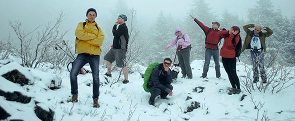
  About half way up to East Peak, we ran into patches of snow which continued sporadically all the way to the peak.  It was an absolutely a beautiful day during the entire hike, and we had seen pictures of a view of Mt. Rainier which was supposedly taken from East Peak.  Unfortunately we were slightly disappointed with the view, which did not rival the view from the Ledge and did not contain Mt. Rainier, when we finally reached the peak.  We had a nice hiking lunch, chatted a bit with a fellow hiker and headed back down the mountain.  The trip down was fairly uneventful except for a small detour where we ventured out onto a rather precarious ledge a little above Rattlesnake Ledge.

This ledge was surrounded on three sides by a several hundred foot drop.  It has been a long time since I have been near the edge of something like this, and I have to say that I'm a bit more afraid of heights at this point in my life than I remember having been in the past.  Needless to say I was relieved when we made our way off the ledge and back onto the trail.

Overall this was one of the groups favorite hikes, despite the crowds, especially the Rattlesnake Ledge portion of the hike. It has great payoff, the trail is graded well, and it's a very manageable drive.

WTA Link

Tuesday, May 20, 2014

New Background

We've updated the background image it was a view from Rattlesnake ledge, but now it's a photograph I took from Hurricane Ridge on the Olympic Peninsula.

Mt. Si via Boulder Garden Loop and Old Si Trail


Mt. Si - April 27th, 2014
Mileage: 8.4 miles
Elevation Gain: 3150 feet
Snoqualmie Pass - North Bend Area
Dog Friendly
Difficulty: Intermediate
Pass Required: WA Discover Pass

The pacific Northwest is a paradise for anyone who likes the outdoors.  From many locations in Washington, Oregon and British Columbia you can hop in your car any day of the year and have relatively fast access to an enormousness amount of different landscapes and biodiversity including snow capped mountains, the pacific ocean and sound, deciduous rain-forests and desert. 

One of the few problems you encounter in this region is snow in the mountains...  Snow that stays way into the summer months in many of the regions we like to hike.  I'm sure if you grew up or spent any time in a mountainous region, you probably wouldn't be surprised to run into a trail that was impassable because of snow coverage in July, but having grown up in the South, I still have a hard time wrapping my brain around the fact that I have to worry about snow in the summer.

Because of the snow, many of our favorite mountain hikes don't open up until very late in summer, which means we are left with very limited options when we want to do a hike with any elevation gain.  One of these options is Mt. Si which is mostly clear of snow, except at the very top, quite early in the season.  This was the third time I've taken the hiking group up Mt. Si already this season.  Luckily, there are three different ascent options for this particular mountain.  On our latest hike we decided to take the old trail which is no longer maintained and much more difficult and technical than the newer trail.

The old trail ended up being difficult enough that about halfway through the hike, I was starting to wonder if I was going to scare some of the members of the hiking group away from future hikes!  This was the second consecutive hike we did that weekend and most of the members who attended the first hike at Rattlesnake Ledge also came to this hike.  As a result, some of the members who haven't been hiking as much this season, as well as some who have, were completely exhausted by around mile 3.  The weather was also challenging on everyone's moral.  It started raining almost immediately after we arrived at the trail-head and the rain proceeded to turn into snow as the temperature dropped below freezing  at about 3000 ft.

Luckily everything ended up being OK in the end. We took lots of breaks, had some food and slowed the pace down significantly and everyone was able to make it to the summit in one piece.  Everyone was so tired by the time we reached the summit that we made a group decision to take the newer, well maintained trail on the way down.  The only downside of this option was that by taking this trail we would arrive at a parking lot that was 2 miles away from where our vehicles were parked.  We decided I would either walk to get one of the cars or hitchhike.  I ended up walking which increased my total mileage for the day to 10.4.  Lets just say I slept like a baby that night!

Overall it was a very difficult, but still very enjoyable hike.  I was quite pleased with the reactions of everyone I hiked with after we were talking about the hike a few days later.  The group consensus was that we need to train more rather than do easier hikes, a sentiment that mirrored what I was thinking.

Skyline Lake Snowshoe


Skyline Lake Snowshoe - April 14th and again May 13th, 2014
Mileage: 3.5 miles
Elevation Gain: 1400 feet
Central Cascades - Stevens Pass
Dog Friendly
Difficulty: Very Difficult
Recommendations: Winter survival training and gear 
Special Requirements: Snowshoes and ice axe

Editor's Note:
Katie and I did this snowshoe for the first time more than a month ago and she was awesome enough to write hikingtrailsandpuppytales' first guest post below. I liked the snowshoe so much that I took Allison and our buddy Nick up to do it again a week ago. The below post contains photos from both trips.

Chris and I decided to do another weekday hike prior to me leaving for vacation. I let him choose where we would be going and planned to meet around 9 AM the following morning. The hike was almost canceled due to an injury that morning, but Chris made a speedy recovery and we were off on our adventure. 

Katie at the top of the world!


We stopped at Sports Authority to rent our snow shoes (only $10!) and poles. We then headed towards Steven's Pass. We parked in the lot across from the ski area and headed toward the trail head. We strapped on the snow shoes almost immediately and quickly set to work. 

Steven's Pass ski resort parking lot (beginning of the hike)
The hike was a lot more steep and strenuous than I had anticipated and the altitude did not help. We had to take several breaks throughout, but we soldiered on. The snowshoes were really cool and allowed us to hike through steep hills covered in deep snow with ease. 

It was easy to keep up with the trail for the first bit, but we were unsure of the trail about halfway up. We decided to just continue uphill following tracks from other hikers. According to the WTA website the snow-covered lake was supposed to be 0.5 mile from the trail head, however we never saw any sign of the lake. We reached an open area with marvelous mountain views and were almost ready to head back down, but spotted another set of tracks heading through the woods to a peak above and decided we still had the energy to continue on. 

Nick at the top
We followed the tracks uphill on what appeared to be a 45 degree angle at times, but our snowshoes dug right in and we made our own set of stairs in the snow. After a short, steep hike we reached our summit. It was magnificent. We had mountain views all around, clear, blue skies, and white snow on the ground. It felt like a huge accomplishment to get to an area of the mountain where not many people had recently traversed and the view was a great reward for all our hard work. The descent was a little more treacherous and led to a lot of sliding down on our butts (some planned, some not), but we made it back to the parking lot without any major issues. 

The second time we did this hike we brought Jaxxon with us.  We purchased a pair of booties for his feet, which ended up being a bit too small to stay on properly.  Luckily we were doing it late enough in the season that it was quite warm (75° F).  So, he was quite happy to be running around in the snow for hours.  If you are hiking with your dogs in snow, especially in lower temperatures, you need to be very careful to take care of your dogs paws.  You should have booties for your dog when doing extended snow hiking.  If you can't get booties or your dog won't allow them to stay on, you should check your dogs paws every 30 minutes to make sure they aren't being rubbed raw or bleeding because of ice crystals in the snow and also check between the pads to make sure ice isn't forming as this can lead to frostbite.
The road where we began the hike from the summit